Rincon Hill Plan
Status: Completed
The Rincon Hill Area Plan – a Sub Area Plan of the Downtown Plan, was adopted in August 2005 into the General Plan.
The goal of the new Rincon Hill Plan is to encourage the ongoing transformation of the area into a new mixed-use residential neighborhood adjacent to the downtown, with both strong urban design controls and implementing mechanisms to fund the necessary public infrastructure, including open space, streets, community facilities, and affordable housing.
The goal of the new Rincon Hill Plan is to encourage the ongoing transformation of the area into a new mixed-use residential neighborhood adjacent to the downtown, with both strong urban design controls and implementing mechanisms to fund the necessary public infrastructure, including open space, streets, community facilities, and affordable housing.
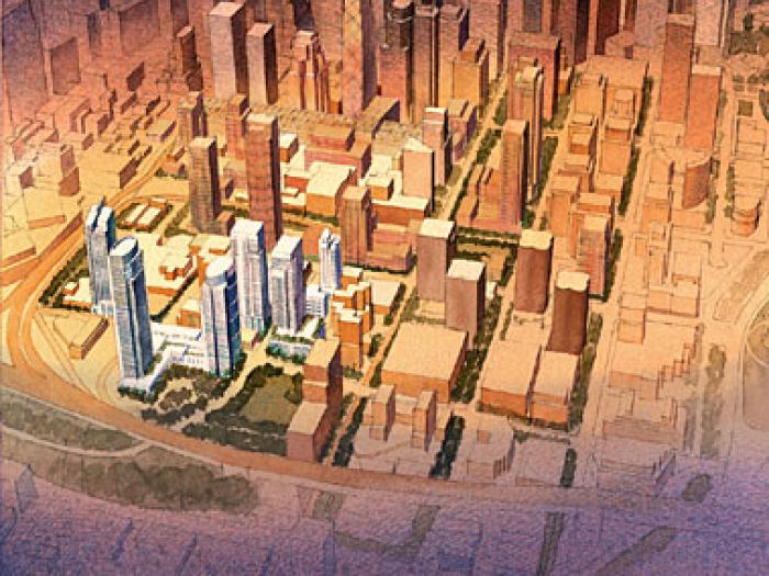
The Rincon Hill Plan provides the blueprint for a dynamic new neighborhood to take shape just south of downtown. Together with plans for the Transbay area, it will create housing for as many as 20,000 new residents. The plan calls for retail shops and neighborhood services along Folsom Boulevard, and transforming Main, Beale, and Spear Streets into traffic-calmed, landscaped residential streets lined with townhouses and front doors. Funding is also included, from development impact fees, for the acquisition and development of open space in the district.
This plan was the first neighborhood plan adopted by the Planning Commission in more than 10 years. It ensures top-quality residential development at a neighborhood scale, with 4 to 8 story buildings on the street and slender residential towers interspersed at heights ranging from 250 to 550 feet. The tallest towers are slated for the top of Rincon Hill, where they will form a distinctive new element on the City's skyline. Standards for tower bulk and spacing are designed to maximize light and air and to frame dramatic views to and from the district.
The plan is the culmination of extensive public planning. Starting in 2003, more than 30 workshops, hearings and walking tours solicited the input of existing residents and businesses, advocates and other public agencies. The result is a plan that balances Rincon Hill's potential to provide much-needed housing with the design requirements of a livable neighborhood.
By establishing a clear blueprint for change, the Plan creates certainty for the development community and the neighborhood. Projects representing 75% of the plan's housing potential have already been submitted for approval.
- 2,220 new housing units, including 266 to 377 new affordable units.1 New affordable housing will be located entirely in the South of Market area. This adds to the 1,455 units already approved for projects at 201 Folsom and 300 Spear Street, including 254 to 360 affordable units.
- Funding for more than $22 million in public improvements via a Rincon Hill Community Infrastructure Impact Fee ($11 per square foot) to pay for widened tree-lined sidewalks on Main, Beale, Spear, Fremont, Harrison, and First Streets, public pedestrian mid-block pathways, a community center at the Sailor's Union for the Pacific Building, and new neighborhood parks. An additional $14 per square foot SOMA Stablization Fee will support affordable housing, small business programs, and community development programs in the South of Market.
- Strong urban design guidelines that require transparent storefronts along Folsom Street, and residential townhouses with stoops and landscaping along other streets.
- Slender residential towers at the peak of Rincon Hill, accentuating the city's skyline and marking the foot of the Bay Bridge.
- Strict standards for tower bulk and spacing to maximize light and air within the district, and preserve views to and from the downtown and the Bay Bridge.
- Improvements to traffic flow, including traffic-calming on residential streets, planted medians, and signage to smooth both neighborhood and regional traffic movement.
- Requirements for all parking to be underground, and standards for residential parking up to a maximum of 1 car per 2 units "by right", or up to 1 car per unit through Planning Commission review if parking spaces are stored with mechanical stackers or valet.
- Public fiscal benefit estimated at $29.7 million in annual property tax revenue, $6 million in one-time school fees, and $18.4 million in transfer taxes at initial sale.
1 Depending on whether the units are provided on- or off-site, as allowed by the City's Planning Code.
Project Schedule and Public Process
| 2000 - 2003 | Preliminary Planning and Concept Development |
| November 2003 | Rincon Hill Plan: Draft for Public Discussion released |
| December 2003- March 2004 | Series of public workshops, walking tours, and staff open working hours to refine the Draft Plan |
| January 21, 2004 | Public EIR Scoping Meeting |
| March 2004 | Proposed Draft Plan Refinements released |
| September 2004 | Draft EIR released |
| November 2004 | Public Hearing on Plan EIR |
| March 2005 | Final Supplement to the Rincon Hill Draft Plan released |
| April 8, 2005 | Comments and Responses for EIR released |
| April 21, 28, and May 5, 2005 | Planning Commission hearings on Rincon Hill Plan |
| May 5, 2005 | Planning Commission adopts General Plan, Planning Code, and Zoning Map amendments related to new Rincon Hill Plan |
| July-August 2005 | Hearings on Rincon Hill Plan at Board of Supervisors Land Use and Finance Committees |
| August 2, 2005 | Board of Supervisors approves new Rincon Hill Plan on first reading |
| August 19, 2005 | Mayor signs new Rincon Hill Plan into law |
Final adopted Area Plan and Planning Code amendments
- Rincon Hill Area Plan
- Final General Plan Amendments for the Rincon Hill Plan
- Final Planning Code Amendments for the Rincon Hill Downtown Residential District and related fees
Other Resources
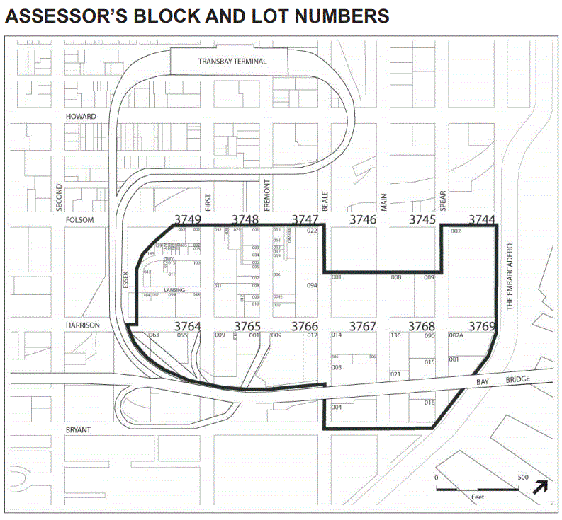
The Rincon Hill area is south of the Financial District and north of the South Beach neighborhood. The area is bounded by Folsom Street, The Embarcadero, Bryant Street, Beale Street, the Bay Bridge approach, and the Transbay Terminal ramps. The area contains approximately 55 acres of land, and includes more than 70 parcels.